Welcome to
GuffeyNews.com
Official web site of the Guffey
Community Association
.jpg)
Welcome to Official web site of the Guffey |
|
Cemetery Project
The goals of the GCA, with regards to the Guffey Cemetery, are to have it designated a Historic Site, clean up the area, and obtain the property from the current owner so it can be passed on to Park County. The GCA is currently looking into who all are buried in the cemetery with the goal of marking their graves with names and dates. We hope to learn as much as possible about the individuals and document what we learn about them on this page. We will, if possible, inform their living descendents of our actions. We are currently using Ancestry.com to gain more information on these folks and their descendents and will contact them, if possible, for additional information. We want to learn from these descendents as much as possible about their buried ancestors, especially about their time spent here in Guffey and possibly what they did for a living. In addition, we would like to have the cemetery area surveyed so that the true boundaries are marked.
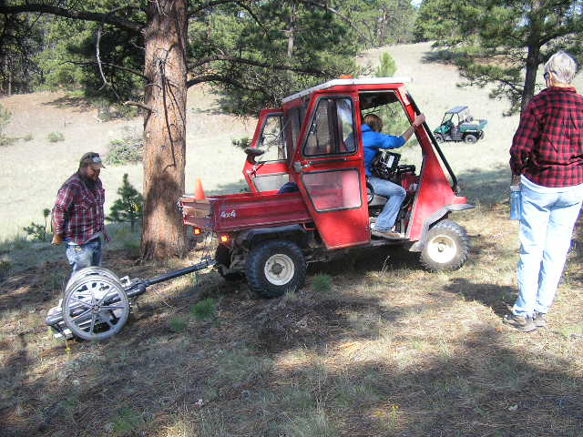
What we have done as of Aug. 17, 2012 --- In preparation for the ground penetration radar survey to look for unmarked grave sites, we have been removing low hanging tree branches so the radar equipment can get close to the trees. On Thursday, Aug. 16, Gregg Kahsar, Mine Engineer, and Hannah Karlsson, Geotechnical Intern, both from the CC&V Gold Mine, Ironclad Office in Cripple Creek, CO, volunteered their time and the company's equipment to run a ground radar survey looking for unmarked graves. What they found was a big surprise for us. Although we thought there were about 20 unmarked graves, we thought they were somewhere in the vicinity of the known graves. But there were very few unknown graves close to the existing graves. Rather, Gregg and Hannah found about 20 graves at the other end of the cemetery. We are thinking that maybe the wealthier people were buried on the hillside in the trees with headstones and the poorer people were buried down the hill in the sun with maybe only wooden grave markers that have long since disappeared. That's only speculation but it is kind of puzzling as to why the graves are separated this way.
Gregg looking at the radar antenna and Hannah looking at the display console.
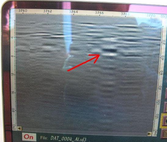
It's all in the ability to interpret the wiggles, waves and bumps. The red arrow points to a grave. The radar is looking for differences in density and this is a definite abrupt change in density at the depth at which there would be a casket. Being able to run this equipment and interpret what they see is why Gregg and Hannah get paid the big bucks.
We certainly want to thank Gregg and Hannah and the CC&V Gold Mine for their generous help with our Guffey Cemetery project.
What we have done as of Dec. 12, 2011 --- In addition to the behind the desk research work (see the files below), we've made a few trips to the cemetery to assess the clean up work that will be required next spring. We've also found, what appears to be, two of the cemetery survey corner pins from one of the surveys completed in the late 1960s or early 1970s.
What we are working on now --- We are attempting to find a generous surveyor who will do a pro bono survey of the cemetery so we are sure of the boundaries in which we need to work. We will also be working to find a person who will do a ground radar survey so that the unmarked graves can be located and marked.
We are working with the daughter of deceased Jerry Mills, the former property owner, to see if the 5 acre cemetery plot can be transferred to the County as a Historic Site. This property is presently in probate so it will be a long process.
In the spring/summer, unless there are some snags that keep us off of the property, we will start to clean up the property and photograph the grave sites (before and after clean up) and post the head stone photos on this page.
Guffey cemetery committee (16 KB)
Cemetery Grave Locations (302 KB)
Cemetery Mapping (53.2 KB)
Guffey Town Plat (207 KB)
Cemetery corner pins (243 KB)
Deeds
Gustave Cohen 1897 Deed (1.17 MB) Transfer of 110 acres (now town of Guffey) from US Government to Gustave Cohen.
Cover Mtn. Subdivision Deed transfers from 1942 through 1969 to the Cover Mtn. Developer. These land transfers contain the 5 acre cemetery. Stahl to Johnson Deed (109 KB) Part of 1943 transfer of property (now Cover Mtn.) from Stanley R. Stahl to Dean F. Johnson. Johnson to Norris Deed (154 KB) 1956 transfer of property (now Cover Mtn.) from Dean F. Johnson to Robert C. Norris Norris to Mills Ranches Deed (341 KB) 1967 transfer of property (now Cover Mtn.) from Robert C. Norris to Mills Ranches Mills Ranches to Sports Enterprises Limited Deed (111 KB) 1969 transfer of property (now Cover Mtn.) from Mills Ranches to Sports Enterprises Limited
Interesting tidbits:
W. T. Boutwell, buried in Guffey Cemetery:
|
|
Thanks to Don Davis for researching and compiling this piece of history. |
|||||||||||||||||||||||||||||
This page last updated on 8-18-2012
.JPG)